WORKS WILL GIVE SAFER HAVEN FROM NOTORIOUS PENTLAND SEAS
Using Gills harbour means avoiding treacherous tidal races
Gills Harbour’s operators intend to fully participate in safe tidal energy cost-reduction by providing upgraded Inner Basin facilities, to allow for all-tides, overnight or longer-term berthing by 24-metre class many-purpose workboats, commonly known as multi-cats.
This is a port improvement on a micro-scale, in global terms.
But it is one that will form an integral component in the future of economic tidal-stream electricity generation in the UK, where the Pentland Firth will continue as a key test-bed proving site of world importance for at least the next two decades.
For the nascent industry’s international “eyes” — and not least media outlets of all sorts — are on Atlantis RL’s Inner Sound MeyGen site.
Those will also be watching the Pentland Firth’s main, deeper water, shipping channel, in the 2020s, as its status as a world-class tidal-stream electricity proving area continues to grow.
This will see Gills becoming a significant, sustainable, support base for such small craft on the Pentland Firth’s southern shores for local, national and international benefit.
Steel-built, rectangular-hull, powerful and versatile multi-cats (or near-equivalents) are expected to play numerous, many-purpose roles in seabed tidalstream power-station construction and maintenance for decades to come.
Multi-cat use varies from towage; as platforms for sub-sea surveying and ROV operations; assisting in cable-handling; some lifting tasks, whilst also being utilised for transporting light loads and personnel movements of specialist technicians.
As well as fuel-economy due to its location, Gills Harbour will offer improved human productivity and safety for on-board crews and technical specialists.
Using Gills will mean that there is no need for fuel-expensive two-hourly daily diversions to other mainland ports from the MeyGen site, thus effectively adding cots or slashing the working day.
Those are important matters in the Pentland Firth, with its deserved rough seas reputation and its potentially deadly tide-races, known locally and to mariners as roosts.
Perhaps those important attributes should be monetarised?
Crews and technicians on those powerful 24/25-metre mini-ships operating from Gills in the Inner Sound will not have to endure seasick-prone multi-cat trips routinely transiting the Pentland Firth’s notorious tidal races to access other mainland ports.
These tide-races include The Merry Men of Mey and The Bore of Duncansby, the fearsome duo of roosts emanating from just off the firth’s Caithness Scottish mainland coast.
Multi-directional white-water waves break daily year-round on these natural phenomena, on the appropriate daily 12.5 hour tidal-stream cycle.
Sea-surface conditions becomes extreme when swift tide-stream flows are opposed by strong winds and long-fetch, wind-induced swells, such as those originating from the 2,500-mile-wide North Atlantic Ocean.
Those big swells are normally driven by the prevailing east-bound track of atmospheric depressions (lows) from the Atlantic over the North of Scotland, especially in winter.
Sea-sickness, or fear of it, is known to be a major disincentive to sea-going skilled staff recruitment — and subsequent retention — in offshore wind-farms in the southern North Sea.
An enhanced Gills Harbour Inner Basin will eliminate that negative for Inner Sound/Pentland Firth tidal-stream electricity works — all four seabed sites so far leased by the Crown Estate in the Pentland Firth lie well clear (i.e. to the east) of The Merry Men of Mey roost.
De-risking the hazards of Pentland Firth to the absolute minimum — which is no more than sea-going technicians have a right to expect — must mean making maximum use of the Inner Basin of the adjacent little port of Gills for mini-ship tidal-stream energy operations.
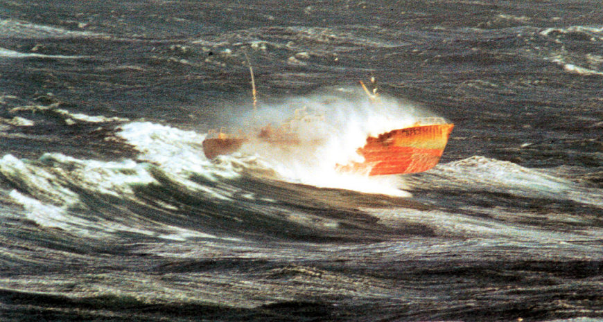
At The Merry Men of Mey, crests of eight or more metres are commonplace in winter, a Scottish “double deaths investigation” court hearing (FAI) was told in 2009.
No-one will ever know with certainty the height of the rapid, massive swells coming from many directions, that led to the sudden capsizing of the 80-metre coaster Cemfjord, with the tragic loss of all eight hands, in a storm-force westerly hurricane on January 2, 2015, in this roost off the north-west end of Stroma, the 1,000-acre mid-firth isle.
It was not navigational ignorance that led to the cargo-ship turning turtle before any emergency “Mayday” radio distress call could be made by her doomed crew; her captain was on his 99th Pentland Firth transit.
There is agreement amongst all interested parties that Gills Harbour’s Inner Basin needs to be deepened by rock-dredging down to minus 2.5 metres at LAT (lowest astronomical tide), a one-off operation as there is near-zero sediment deposition there.
Also, that the safe berth(s) for workboats’ overnight stays should be at a new vertical wall-face a few metres seawards from the present South Quay, to which it would be permanently affixed. This new South Quay would be parallel to be present one and thus adjacent to the Highland Council’s main Gills harbour access spur-road that daily carries several 40-tonne articulated trucks.
The new South Quay would handle “light-loads” and packages, while also being suitable for manpower transfers to/from the multi-cats.
More problematic has been the positioning of mini-breakwaters, or pier(s), designed to provide safe entry and egress for beamy multi-cats (hulls are typically 12 metres wide, plus fenders on each side), whilst calming sea-surface turbulence to an absolute minimum (nil or near-nil) in Gills Harbour’s Inner Basin, in all weathers and tidal conditions.
There have been various suggestions as to how to achieve this from civil engineers and knowledgeable harbour users.
Layouts will soon be tested using computerised hydrodynamic “wave characteristic and interaction models” to provide optimum locations for the positioning of these mini-breakwaters.
These procedures are currently (01/02/2017) being undertaken for Gills Harbour Ltd by experienced post-graduate “modellers” from the University of the Highlands and Islands Environmental Research Institute at Thurso, Caithness.
Why Gills provides best Pentland Firth shelter on the Caithness shore
The Pentland Firth has been known as “A Wild and Open Sea” since antiquity, with Gills Bay providing the best natural shelter on its Scottish Mainland side, largely due to natural adjoining coastal topography. But it is not a protected sea-loch or a fjord, nor an islands-screened “inland sea”, like Scapa Flow in Orkney.
Today, this is much assisted by Gills’ three-part recycled 200-metre-long ferry breakwater/berth, a linked finger-pier provided entirely from private funds by Pentland Ferries Ltd, that keeps Atlantic-origin big westerly swells at bay.
Secondly, by the fact that the Merry Men of Mey acts as a swell-dampening kind of “natural floating breakwater”.

It is 1.5-mile wide stretch of major sea-surface turbulence, “working” on the (west-flowing) ebb-tide and spanning the whole firth (7 miles to Orkney).
The roost’s furious breaking waves absorb much of the forcefulness of incoming Atlantic-origin swells, thus stilling the sea-surface to near-calm to its eastward.
For 12.5 hours daily, during those ebb streams, this phenomenon, well-known to mariners, shields Gills Bay from the force of sea-storms brought into the Pentland Firth by successive atmospheric “lows” crossing the North of Scotland from the prevailing westerly direction.
Heavy swells can also arrive at the Pentland Firth’s western approaches from distant Atlantic storms, hundreds of miles to the west, whose effects are not otherwise seen in the Gills Bay area.
The layout of the Orkney Islands (7 miles away) and nearby Stroma (1.5 miles) spanning most of its northern horizon, prevents “fetch-waves” from that direction from attaining any significant size in Gills Bay.
Added to that is the fact that Gills Harbour lies half-a-mile inside the main flow of Inner Sound tidal streams.


